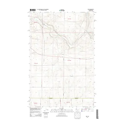
2013 Map of Irby
USGS Topo · Published 2013About this map
Irby serves as the focal point of this Eastern Washington landscape, situated where the waters of Crab Creek flow through the basalt-carved terrain of the Inland Northwest. The settlement pattern is defined by a rigorous grid of section lines and county roads, including Wraspir Rd E and Kagele Rd N, which facilitate movement through the agricultural uplands. The drainage of Lake Cr and the presence of Bobs Lakes in the northeast corner illustrate the unique hydrology of the Channeled Scablands. Stretching across the southern portion of the map, the boundary between Lincoln Co and Adams Co marks a significant political division in this dryland farming region. The alignment of Wa-28 provides the primary east-west arterial, connecting local farm-to-market routes like Batum Rd N and Schafer Rd E to the broader regional transportation network.
Find a feature on this map
28 named features on this map. Tap any name to fly to it.
Don’t see what you’re looking for? This feature index may not catch every label — zoom into the map to look around manually.
Map Details
Editions of this 2013 Irby Map
This is the sole edition of this map. No revisions or reprints were ever made.
Other maps of this area

1925 · Schrag
USGS Topo · 1:62,500

1953 · Ritzville
USGS Topo · 1:250,000

1959 · Ritzville
USGS Topo · 1:250,000

1965 · Ritzville
USGS Topo · 1:250,000
1967 · Ruff
USGS Topo · 1:24,000

1967 · Batum
USGS Topo · 1:24,000

1967 · Reiman
USGS Topo · 1:24,000

1968 · Marlin SW
USGS Topo · 1:24,000

1968 · Irby
USGS Topo · 1:24,000

1968 · Marlin
USGS Topo · 1:24,000