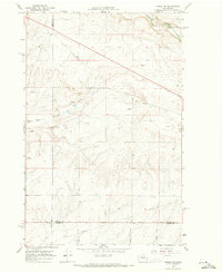
1968 Map of Marlin SW
USGS Topo · Published 1971About this map
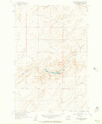
Crab Creek winds through the northern portion of this Columbia Basin landscape, flanked by the heavy steel of the Burlington Northern Railroad. The geography is defined by deep basalt carves and dry watercourses, most notably the prominent Black Rock Coulee that cuts across the western sections. This 1968 survey reveals a sparse, rural infrastructure where life centers on isolated resources like a lone Spring and numerous Gravel Pits that supported local road building and maintenance. The intersection of three counties—Grant, Lincoln, and Adams—meets at precise boundaries in the southern half of the sheet. Industrial footprints are minimal but significant, marked by a cross-country Pipeline and a Radio Tower standing as modern landmarks against the ancient terrain of the Channeled Scablands. A network of county routes, including Davis Road and Moody Road, provides the primary access through this high-desert ranching and transit corridor.
Find a feature on this map
15 named features on this map. Tap any name to fly to it.
Don’t see what you’re looking for? This feature index may not catch every label — zoom into the map to look around manually.
Map Details
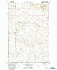
Editions of this 1968 Marlin SW Map
2 editions found
Other maps of this area

1923 · Wheeler
USGS Topo · 1:62,500

1925 · Wheeler
USGS Topo · 1:62,500
1925 · Schrag
USGS Topo · 1:62,500

1953 · Ritzville
USGS Topo · 1:250,000
1956 · Wheeler NE
USGS Topo · 1:24,000
1956 · Wilson Creek SE
USGS Topo · 1:24,000
1956 · Wilson Creek
USGS Topo · 1:62,500
1956 · Wheeler
USGS Topo · 1:62,500

1959 · Ritzville
USGS Topo · 1:250,000

1965 · Ritzville
USGS Topo · 1:250,000