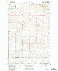
1968 Map of Marlin SW
USGS Topo · Published 1991About this map
Black Rock Coulee and the winding course of Crab Creek dominate this 1960s topographic survey of the Washington interior. The landscape is defined by the unique geological formations of the Channeled Scablands, where the coulee floor is marked by numerous Wells and a scattering of Gravel Pits. Local connectivity is provided by a grid of rural routes including Davis Road, Irby Road, and Moody Road, which traverse the undulating terrain and county lines. A section of Pipeline cuts across the southern portion of the map, illustrating the regional utility infrastructure of the era. Evidence of early habitation and local nomenclature appears in features like Fink and the Radio Tower, while the presence of a Spring near the center of the sheet highlights the importance of water sources in this semi-arid environment.
Find a feature on this map
16 named features on this map. Tap any name to fly to it.
Don’t see what you’re looking for? This feature index may not catch every label — zoom into the map to look around manually.
Map Details
Editions of this 1968 Marlin SW Map
2 editions found

Other maps of this area

1923 · Wheeler
USGS Topo · 1:62,500

1925 · Wheeler
USGS Topo · 1:62,500

1925 · Schrag
USGS Topo · 1:62,500

1953 · Ritzville
USGS Topo · 1:250,000

1956 · Wheeler NE
USGS Topo · 1:24,000

1956 · Wilson Creek SE
USGS Topo · 1:24,000

1956 · Wilson Creek
USGS Topo · 1:62,500
1956 · Wheeler
USGS Topo · 1:62,500

1959 · Ritzville
USGS Topo · 1:250,000

1965 · Ritzville
USGS Topo · 1:250,000