
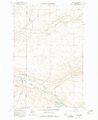
1968 Map of Marlin
USGS Topo · Published 1971About this map
The town of Marlin (Krupp) sits at the junction of rail and water in this late 1960s survey of eastern Washington. Situated along the Burlington Northern line, the settlement is defined by the winding course of Crab Creek and the surrounding coulee landscape. The map captures a transition in the land, where the irrigated valley floors meet the dry upland plateaus. Notable local landmarks include Zion Church and a small Cem located on the higher ground overlooking the valley. The drainage patterns of Canniwai Creek and Gibson Draw converge in the Canniwai Valley, illustrating the complex geological features of the Scablands. To the southeast, Peterson Lake and the expanse of Marlin Hollow emphasize the rural character of the Grant and Lincoln County border during this era of agricultural development.
Find a feature on this map
18 named features on this map. Tap any name to fly to it.
Don’t see what you’re looking for? This feature index may not catch every label — zoom into the map to look around manually.
Map Details
Editions of this 1968 Marlin Map
2 editions found
Other maps of this area

1953 · Ritzville
USGS Topo · 1:250,000

1956 · Wilson Creek SE
USGS Topo · 1:24,000

1956 · Wilson Creek
USGS Topo · 1:62,500

1959 · Ritzville
USGS Topo · 1:250,000

1965 · Ritzville
USGS Topo · 1:250,000

1968 · Marlin SW
USGS Topo · 1:24,000

1968 · Irby
USGS Topo · 1:24,000

1968 · Hartline SE
USGS Topo · 1:24,000

1968 · Sullivan Lake
USGS Topo · 1:24,000

1969 · Almira SE
USGS Topo · 1:24,000