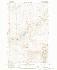
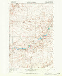
1968 Map of Sullivan Lake
USGS Topo · Published 1971About this map
Marlin Hollow defines the drainage pattern of this high plateau country in Lincoln County, where a series of small, isolated basins and springs provide water in an otherwise arid landscape. This 1968 field-checked survey reveals a territory marked by seasonal hydrology and resource extraction, with numerous Gravel Pits and a Borrow Pit scattered across the township lines. The topography is characterized by a network of drainage features like Canniwai Creek and specific water landmarks such as Reiser Falls and Delzer Falls.
Find a feature on this map
22 named features on this map. Tap any name to fly to it.
Don’t see what you’re looking for? This feature index may not catch every label — zoom into the map to look around manually.
Map Details
Editions of this 1968 Sullivan Lake Map
This is the sole edition of this map. No revisions or reprints were ever made.
Other maps of this area

1953 · Ritzville
USGS Topo · 1:250,000

1959 · Ritzville
USGS Topo · 1:250,000

1965 · Ritzville
USGS Topo · 1:250,000
1968 · Marlin SW
USGS Topo · 1:24,000
1968 · Irby
USGS Topo · 1:24,000
1968 · Marlin
USGS Topo · 1:24,000
1968 · Pacific Lake
USGS Topo · 1:24,000
1968 · Odessa
USGS Topo · 1:24,000
1969 · Almira SE
USGS Topo · 1:24,000
1969 · Almira SW
USGS Topo · 1:24,000