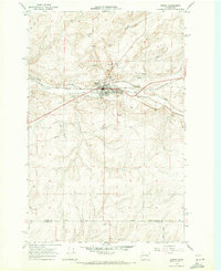
1968 Map of Odessa
USGS Topo · Published 1971About this map
Odessa serves as the focal point of this late 1960s study, situated at the confluence of the Crab Creek valley and the high scablands of the Columbia Plateau. The settlement's layout is defined by the Burlington Northern railroad, which runs parallel to the creek and supports the regional agricultural economy. Notable local infrastructure includes the Odessa Cem, the Municipal Golf Course, and a Radio Facility located on the higher ground north of town.
Find a feature on this map
21 named features on this map. Tap any name to fly to it.
Don’t see what you’re looking for? This feature index may not catch every label — zoom into the map to look around manually.
Map Details
Editions of this 1968 Odessa Map
This is the sole edition of this map. No revisions or reprints were ever made.
Other maps of this area

1925 · Schrag
USGS Topo · 1:62,500

1953 · Ritzville
USGS Topo · 1:250,000

1959 · Ritzville
USGS Topo · 1:250,000

1965 · Ritzville
USGS Topo · 1:250,000

1967 · Schoonover
USGS Topo · 1:24,000

1967 · Batum
USGS Topo · 1:24,000

1967 · Reiman
USGS Topo · 1:24,000

1968 · Irby
USGS Topo · 1:24,000

1968 · Sylvan Lake
USGS Topo · 1:24,000

1968 · Coffeepot Lake
USGS Topo · 1:24,000