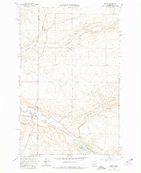
1968 Map of Marlin
USGS Topo · Published 1981About this map
Marlin (Krupp) serves as the primary settlement on this Lincoln County landscape, situated where the Burlington Northern railroad tracks follow the winding path of Crab Creek. The geography here is defined by broad drainages and agricultural depressions, notably the Canniwal Valley and the prominent Marlin Hollow to the east. The map captures a moment in the late 1960s when the region's rural character was firmly established, evidenced by numerous Gravel Pits and isolated water sources like Peterson Lake and several unnamed Spring points.
Find a feature on this map
21 named features on this map. Tap any name to fly to it.
Don’t see what you’re looking for? This feature index may not catch every label — zoom into the map to look around manually.
Map Details
Editions of this 1968 Marlin Map
2 editions found
Other maps of this area

1953 · Ritzville
USGS Topo · 1:250,000

1956 · Wilson Creek SE
USGS Topo · 1:24,000

1956 · Wilson Creek
USGS Topo · 1:62,500

1959 · Ritzville
USGS Topo · 1:250,000

1965 · Ritzville
USGS Topo · 1:250,000

1968 · Marlin SW
USGS Topo · 1:24,000

1968 · Irby
USGS Topo · 1:24,000

1968 · Marlin
USGS Topo · 1:24,000

1968 · Hartline SE
USGS Topo · 1:24,000

1968 · Sullivan Lake
USGS Topo · 1:24,000