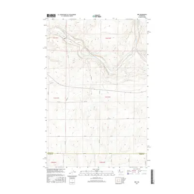
2017 Map of Irby
USGS Topo · Published 2017About this map
Crab Creek winds through the northern portion of this Lincoln County landscape, defining the topography near the small settlement of Irby. This area of eastern Washington is characterized by a high-desert drainage system, where the creek's path is shadowed by Wraspir Rd E and Irby Rd. The map illustrates a rural transport network typical of the early 21st century, with named section lines such as Old Hwy Lp and Graebel Rd providing access to the surrounding plateaus. In the northeast corner, Lake Cr and the Bobs Lakes represent the significant water features of the region. The southern boundary of the quadrangle follows the Lincoln Co and Adams Co line along Davis Rd, anchoring the map to its administrative and geographic borders within the larger agricultural and ranching interior.
Find a feature on this map
29 named features on this map. Tap any name to fly to it.
Don’t see what you’re looking for? This feature index may not catch every label — zoom into the map to look around manually.
Map Details
Editions of this 2017 Irby Map
This is the sole edition of this map. No revisions or reprints were ever made.
Other maps of this area

1925 · Schrag
USGS Topo · 1:62,500

1953 · Ritzville
USGS Topo · 1:250,000

1959 · Ritzville
USGS Topo · 1:250,000

1965 · Ritzville
USGS Topo · 1:250,000
1967 · Ruff
USGS Topo · 1:24,000

1967 · Batum
USGS Topo · 1:24,000

1967 · Reiman
USGS Topo · 1:24,000

1968 · Marlin SW
USGS Topo · 1:24,000

1968 · Irby
USGS Topo · 1:24,000

1968 · Marlin
USGS Topo · 1:24,000