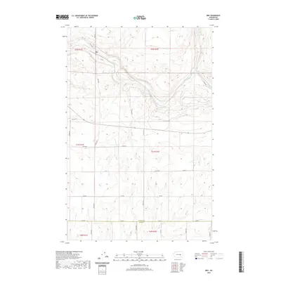
2020 Map of Irby
USGS Topo · Published 2020About this map
Irby serves as the focal point of this Eastern Washington landscape, situated along the meandering course of Crab Creek. The terrain is defined by the unique Coulee geology characteristic of the region, where water features like Bobs Lakes and Lake Cr provide rare moisture in a landscape primarily partitioned into large agricultural blocks. This 2020 edition provides a clear record of the local transportation network, showing how historic routes like Old Hwy Lp and Irby Rd connect the area's rural farmsteads. The southern portion of the map highlights the survey boundary between Lincoln and Adams counties, primarily following Davis Rd. While most of the sheet is occupied by the expansive open country of the Big Bend region, the concentration of family-named roads such as Schafer Rd, Fink Rd, and Kagele Rd N offers a modern link to the long-standing farming families of the plateau.
Find a feature on this map
31 named features on this map. Tap any name to fly to it.
Don’t see what you’re looking for? This feature index may not catch every label — zoom into the map to look around manually.
Map Details
Editions of this 2020 Irby Map
This is the sole edition of this map. No revisions or reprints were ever made.
Other maps of this area

1925 · Schrag
USGS Topo · 1:62,500

1953 · Ritzville
USGS Topo · 1:250,000

1959 · Ritzville
USGS Topo · 1:250,000

1965 · Ritzville
USGS Topo · 1:250,000
1967 · Ruff
USGS Topo · 1:24,000

1967 · Batum
USGS Topo · 1:24,000

1967 · Reiman
USGS Topo · 1:24,000

1968 · Marlin SW
USGS Topo · 1:24,000

1968 · Irby
USGS Topo · 1:24,000

1968 · Marlin
USGS Topo · 1:24,000