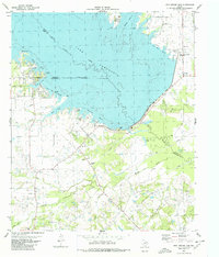
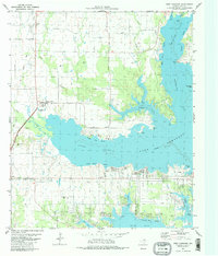
1980 Map of Iron Bridge Dam
USGS Topo · Published 1980About this map
Lake Tawakoni dominates this 1980 survey, showing the complex shoreline formed by the Iron Bridge Dam along the borders of Van Zandt, Hunt, and Rains Counties. The map details numerous named aquatic features like Warloup Reach, Gum Cove, and White Deer Reach, illustrating the recreational and water-management focus of the era. South of the dam, the Sabine River continues its course through a landscape marked by infrastructure including a Filtration Plant and various pipelines.
Find a feature on this map
47 named features on this map. Tap any name to fly to it.
Don’t see what you’re looking for? This feature index may not catch every label — zoom into the map to look around manually.
Map Details
Editions of this 1980 Iron Bridge Dam Map
This is the sole edition of this map. No revisions or reprints were ever made.
Other maps of this area

1954 · Dallas
USGS Topo · 1:250,000

1956 · Tyler
USGS Topo · 1:250,000

1956 · Quinlan
USGS Topo · 1:62,500

1956 · Emory
USGS Topo · 1:62,500

1958 · Dallas
USGS Topo · 1:250,000

1962 · Wills Point
USGS Topo · 1:24,000
1962 · Edgewood
USGS Topo · 1:24,000
1962 · Fruitvale
USGS Topo · 1:24,000
1979 · Ables Springs
USGS Topo · 1:24,000
1980 · West Tawakoni
USGS Topo · 1:24,000