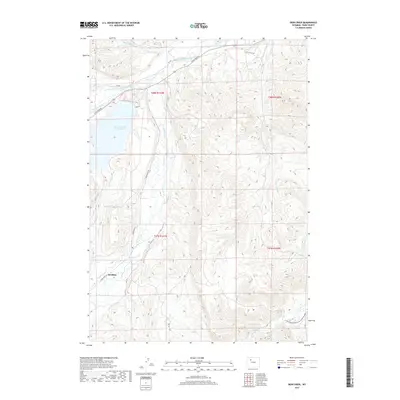
2017 Map of Iron Creek
USGS Topo · Published 2017About this map
Sunshine sits at the western edge of this landscape, positioned where the Wood River flows north toward its confluence with the Greybull River. The terrain is defined by an intricate network of irrigation and water management, essential for life in this part of Park County. High-elevation water storage at Lower Sunshine Reservoir and long-reaching man-made channels like Only Chance Ditch and Pappapau Ditch indicate a region dedicated to ranching and agriculture. The landscape transitions from the river valleys to the high ridges surrounding Iron Cr and Little Buffalo Cr. To the south, the winding course of Gooseberry Cr cuts through the high desert, while a series of remote roads, including the LU Ranch Rd, provide access to the interior oil and cattle country typical of Wyoming's Bighorn Basin during this era.
Find a feature on this map
23 named features on this map. Tap any name to fly to it.
Don’t see what you’re looking for? This feature index may not catch every label — zoom into the map to look around manually.
Map Details
Editions of this 2017 Iron Creek Map
This is the sole edition of this map. No revisions or reprints were ever made.
Other maps of this area
1904 · Kirwin
USGS Topo · 1:125,000
1906 · Kirwin
USGS Topo · 1:125,000
1911 · Meeteetse
USGS Topo · 1:62,500
1913 · Meeteetse
USGS Topo · 1:62,500

1955 · Cody
USGS Topo · 1:250,000

1955 · Thermopolis
USGS Topo · 1:250,000
1956 · Soapy Dale Peak
USGS Topo · 1:24,000
1956 · Adam Weiss Peak
USGS Topo · 1:24,000
1957 · Sunshine Reservoir
USGS Topo · 1:62,500

1958 · Cody
USGS Topo · 1:250,000