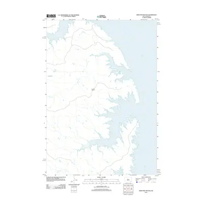
2012 Map of Iron Post Buttes
USGS Topo · Published 2012About this map
Lake Oahe dominates the eastern half of this Stanley County landscape, its expansive waters defining a complex shoreline where the prairie meets the reservoir. Rising above the western drainage basins, the Iron Post Buttes serve as a primary topographic landmark for the region. The map captures a moment in the early 21st century where the vast Missouri River impoundment has reshaped the local geography, creating deep inlets at the mouths of Sand Cr and Mission Cr. This transition from high plains to water-level and riparian systems is further evidenced by the course of Agency Cr in the south. Human footprint in this area remains sparse and largely agricultural, centered on established sites like the Donelan Ranch, reflecting the enduring ranching character of central South Dakota.
Find a feature on this map
6 named features on this map. Tap any name to fly to it.
Don’t see what you’re looking for? This feature index may not catch every label — zoom into the map to look around manually.
Map Details
Editions of this 2012 Iron Post Buttes Map
This is the sole edition of this map. No revisions or reprints were ever made.
Other maps of this area

1954 · Pierre
USGS Topo · 1:250,000

1958 · Pierre
USGS Topo · 1:250,000

1969 · Rousseau Creek
USGS Topo · 1:24,000

1969 · No Heart Creek SE
USGS Topo · 1:24,000

1969 · No Heart Creek SW
USGS Topo · 1:24,000
1973 · Iron Post Buttes SE
USGS Topo · 1:24,000

1973 · Iron Post Buttes SW
USGS Topo · 1:24,000

1973 · Iron Post Buttes
USGS Topo · 1:24,000
1973 · Mail Shack Creek
USGS Topo · 1:24,000

1982 · Mission Ridge
USGS Topo · 1:24,000