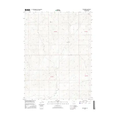
2016 Map of Iron Springs
USGS Topo · Published 2016About this map
Iron Springs and the drainage network of Lay Cr define this pocket of Moffat County, where the high desert terrain is carved by seasonal watercourses and deep ravines. The landscape is marked by the distinct topographic features of Bord Gulch and Dressier Gulch, which drop from the higher ridges down toward the creek valleys. A sparse network of county roads, including Co RD 17 and Co RD 8, provides the primary access through this rangeland, connecting the various township and range sections. The map reveals the intricate contouring of the region, showing how Spring Cr and its tributaries navigate the complex elevations of the T9N and T8N boundaries. This 2016 survey captures a quiet, working landscape where the geography of the water and the reach of the local road system are the primary indicators of land use and human presence.
Find a feature on this map
13 named features on this map. Tap any name to fly to it.
Don’t see what you’re looking for? This feature index may not catch every label — zoom into the map to look around manually.
Map Details
Editions of this 2016 Iron Springs Map
This is the sole edition of this map. No revisions or reprints were ever made.
Other maps of this area
1916 · Craig
USGS Topo · 1:125,000

1954 · Craig
USGS Topo · 1:250,000
1957 · Craig
USGS Topo · 1:250,000
1958 · Craig
USGS Topo · 1:250,000
1960 · Craig
USGS Topo · 1:250,000
1962 · Craig
USGS Topo · 1:250,000
1964 · Craig
USGS Topo · 1:250,000
1965 · Craig
USGS Topo · 1:250,000
1969 · Adobe Springs
USGS Topo · 1:24,000
1969 · Great Divide
USGS Topo · 1:24,000