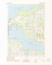
1983 Map of Ironton
USGS Topo · Published 1984About this map
Lake Michigan and Lake Charlevoix meet at the strategic channel of Charlevoix, where this early 1980s survey captures a landscape defined by its deep-water access and coastal topography. The township of Hayes dominates the northern peninsula, featuring the Big Rock Powerplant at Big Rock Point and the inland waters of Susan Lake. To the south, the settlement of Ironton anchors the entrance to the south arm of the lake, showing the local ferry crossing at Ferry Road. The map reveals a mix of residential growth and preserved history, such as the Greensky Hill Ch and the high ground of Mount McSauba. Numerous family-named landmarks and routes, like Wickersham Road and Hemingway Point, trace the long-standing land divisions and shoreline estates that characterize this portion of the northern Michigan coast.
Find a feature on this map
53 named features on this map. Tap any name to fly to it.
Don’t see what you’re looking for? This feature index may not catch every label — zoom into the map to look around manually.
Map Details
Editions of this 1983 Ironton Map
2 editions found
Other maps of this area

1954 · Central Lake
USGS Topo · 1:62,500

1954 · Charlevoix
USGS Topo · 1:62,500

1955 · Cheboygan
USGS Topo · 1:250,000

1958 · Cheboygan
USGS Topo · 1:250,000

1958 · Bayshore
USGS Topo · 1:62,500

1961 · Boyne City
USGS Topo · 1:62,500

1975 · Boyne City NW
USGS Topo · 1:24,000

1975 · Boyne City NE
USGS Topo · 1:24,000
1983 · Ellsworth
USGS Topo · 1:25,000
1983 · Forest Beach
USGS Topo · 1:25,000