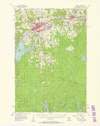
1955 Map of Ironwood
USGS Topo · Published 1961About this map
The Montreal River forms a jagged border between Michigan and Wisconsin, anchoring a landscape defined by the heavy industry of the Gogebic Range in the mid-1950s. The twin cities of Hurley and Ironwood dominate the central corridor, surrounded by numerous mining settlements like Jessieville, Norrie, and Aurora. Evidence of the region’s iron-ore heritage is everywhere, from mine dumps near Yale to the Old Colby Mine and Old Tilden Mine near Bessemer.
Find a feature on this map
89 named features on this map. Tap any name to fly to it.
Don’t see what you’re looking for? This feature index may not catch every label — zoom into the map to look around manually.
Map Details
Editions of this 1955 Ironwood Map
2 editions found

Other maps of this area

1939 · Winchester
USGS Topo · 1:48,000

1940 · Mercer
USGS Topo · 1:48,000

1940 · Butternut
USGS Topo · 1:48,000

1940 · Upson
USGS Topo · 1:48,000

1943 · Little Girls Point
USGS Topo · 1:24,000

1943 · Upson
USGS Topo · 1:48,000

1943 · Ironwood
USGS Topo · 1:48,000

1943 · Little Girl Point
USGS Topo · 1:48,000

1945 · Mercer
USGS Topo · 1:48,000

1946 · Winchester
USGS Topo · 1:48,000