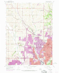
1956 Map of Irvington
USGS Topo · Published 1970About this map
Boys Town and the developing western suburbs of Omaha define this mid-century landscape as the city expanded northward and westward. The mapping documents a period of rapid infrastructure growth, where the purple revisions of 1969 show significant urban extensions into formerly rural sections like Union and Jefferson. The transportation network is anchored by the Chicago and North Western railroad and new highway construction, which began to reshape the valley of Little Papillion Creek.
Find a feature on this map
95 named features on this map. Tap any name to fly to it.
Don’t see what you’re looking for? This feature index may not catch every label — zoom into the map to look around manually.
Map Details
Editions of this 1956 Irvington Map
5 editions found
Other maps of this area

1893 · Omaha
USGS Topo · 1:62,500

1893 · Fremont
USGS Topo · 1:125,000

1896 · Fremont
USGS Topo · 1:125,000

1954 · Omaha
USGS Topo · 1:250,000

1955 · Fremont
USGS Topo · 1:250,000

1956 · Gretna
USGS Topo · 1:24,000

1956 · Ralston
USGS Topo · 1:24,000

1956 · Irvington
USGS Topo · 1:24,000

1956 · Omaha North
USGS Topo · 1:24,000

1956 · Omaha South
USGS Topo · 1:24,000