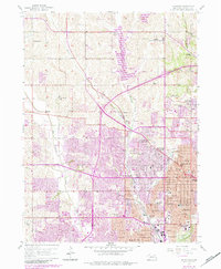
1956 Map of Irvington
USGS Topo · Published 1984About this map
The northwest expansion of Omaha and the suburban growth in Douglas County are documented in this mid-century survey, photorevised in the early 1980s. The landscape is defined by the drainage of Big Papillion Creek and Little Papillion Creek, with the prominent addition of Glenn Cunningham Lake impacting the northern terrain. Significant institutional landmarks are scattered throughout the region, including the famous Boys Town campus and the St James Orphanage.
Find a feature on this map
44 named features on this map. Tap any name to fly to it.
Don’t see what you’re looking for? This feature index may not catch every label — zoom into the map to look around manually.
Map Details
Editions of this 1956 Irvington Map
5 editions found
Other maps of this area

1893 · Omaha
USGS Topo · 1:62,500

1893 · Fremont
USGS Topo · 1:125,000

1896 · Fremont
USGS Topo · 1:125,000

1954 · Omaha
USGS Topo · 1:250,000

1955 · Fremont
USGS Topo · 1:250,000

1956 · Gretna
USGS Topo · 1:24,000

1956 · Ralston
USGS Topo · 1:24,000

1956 · Irvington
USGS Topo · 1:24,000

1956 · Omaha North
USGS Topo · 1:24,000

1956 · Omaha South
USGS Topo · 1:24,000