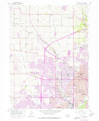
1956 Map of Irvington
USGS Topo · Published 1977About this map
Boys Town and the expanding western fringes of Omaha define this mid-century landscape, where rural Nebraska section lines meet the post-war growth of Douglas County. The Chicago and North Western railroad cuts diagonally across the terrain, passing through the village of Irvington and near the Omaha Air Force Station. Significant social and community landmarks are scattered throughout, including the St. James Orphanage, Mt Hope Cemetery, and St Timothy Church.
Find a feature on this map
79 named features on this map. Tap any name to fly to it.
Don’t see what you’re looking for? This feature index may not catch every label — zoom into the map to look around manually.
Map Details
Editions of this 1956 Irvington Map
5 editions found
Other maps of this area

1893 · Omaha
USGS Topo · 1:62,500

1893 · Fremont
USGS Topo · 1:125,000

1896 · Fremont
USGS Topo · 1:125,000

1954 · Omaha
USGS Topo · 1:250,000

1955 · Fremont
USGS Topo · 1:250,000

1956 · Gretna
USGS Topo · 1:24,000

1956 · Ralston
USGS Topo · 1:24,000

1956 · Irvington
USGS Topo · 1:24,000

1956 · Omaha North
USGS Topo · 1:24,000

1956 · Omaha South
USGS Topo · 1:24,000