1935 Map of Irwin
USGS Topo · Published 1935About this map
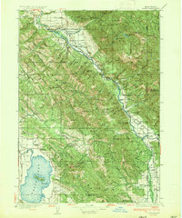
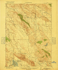
Irwin and the surrounding high country of the Caribou Range dominate this mid-1930s survey along the Idaho-Wyoming border. The Snake River carves a deep path through the Grand Valley, supported by essential river crossings like Edwards Ferry and early infrastructure like State Highway No 22. This was a landscape of small, dispersed communities and mountain industry, evidenced by the Weeks Saw Mill near the Snake River Range and a dense network of rural schoolhouses such as Fidelity Sch and Rainy Dale Sch.
Find a feature on this map
83 named features on this map. Tap any name to fly to it.
Don’t see what you’re looking for? This feature index may not catch every label — zoom into the map to look around manually.
Map Details
Editions of this 1935 Irwin Map
3 editions found

Other maps of this area

1899 · Grand Teton
USGS Topo · 1:125,000

1901 · Grand Teton
USGS Topo · 1:125,000
1914 · Henry
USGS Topo · 1:48,000

1915 · Freedom
USGS Topo · 1:62,500

1915 · Lanes Creek
USGS Topo · 1:62,500
1916 · Henry
USGS Topo · 1:62,500
1917 · Cranes Flat
USGS Topo · 1:62,500

1921 · Afton
USGS Topo · 1:125,000

1924 · Hell Creek
USGS Topo · 1:62,500

1926 · Hell Creek
USGS Topo · 1:62,500