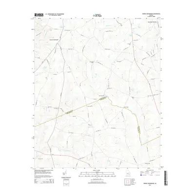
2014 Map of Irwins Crossroads
USGS Topo · Published 2014About this map
The Ohoopee River winds south through the borderlands of Washington and Johnson counties, defining the character of this rural Georgia landscape. The map centers on the small hub of Irwins Crossroads and the settlement at Peacocks Crossing, where local travel is anchored by historic river crossings like Masseys Mill Bridge, Harts Ford Bridge, and Daniel Bridge. The distribution of rural cemeteries such as Old Bethesda Cem, Bethany Cem, and Mt Gilead Cem reflects generations of family settlements along the various branches and creeks, including Little Buckeye Cr and Dyers Cr. Numerous ponds, such as Hodges Pond, Turners Pond, and Morgans Pond, are scattered across the terrain, indicating a landscape heavily integrated with local agriculture and water management. This 2014 survey documents the enduring road network, from state routes like Ga-15 to local passages like Wommack Ln and Bertha Martin Rd, that connects these dispersed farmsteads and historic family landmarks.
Find a feature on this map
85 named features on this map. Tap any name to fly to it.
Don’t see what you’re looking for? This feature index may not catch every label — zoom into the map to look around manually.
Map Details
Editions of this 2014 Irwins Crossroads Map
This is the sole edition of this map. No revisions or reprints were ever made.
Other maps of this area

1957 · Macon
USGS Topo · 1:250,000

1958 · Macon
USGS Topo · 1:250,000

1962 · Oconee
USGS Topo · 1:24,000

1962 · Irwins Crossroads
USGS Topo · 1:24,000

1962 · Tabernacle
USGS Topo · 1:24,000

1962 · Sandersville
USGS Topo · 1:24,000

1964 · Macon
USGS Topo · 1:250,000
1973 · Riddleville
USGS Topo · 1:24,000
1973 · Harrison
USGS Topo · 1:24,000

1974 · Cow Hell Swamp
USGS Topo · 1:24,000