
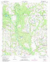
1973 Map of Irwinville
USGS Topo · Published 1975About this map
Jefferson Davis Memorial State Park serves as a significant historical landmark in this region of South Georgia, marking the site where the Confederate president was captured. The surrounding landscape is defined by the winding Alapaha River and a dense network of water bodies, including the recreation-focused Crystal Lake with its adjacent Crystal Lake Airpark and Campgrounds. These features, alongside Big Bend Lake and Tenmile Trail Lake, suggest a mid-century shift toward seasonal tourism and outdoor leisure.
Find a feature on this map
57 named features on this map. Tap any name to fly to it.
Don’t see what you’re looking for? This feature index may not catch every label — zoom into the map to look around manually.
Map Details
Editions of this 1973 Irwinville Map
2 editions found
Other maps of this area

1953 · Waycross
USGS Topo · 1:250,000

1958 · Waycross
USGS Topo · 1:250,000

1973 · Ocilla West
USGS Topo · 1:24,000

1973 · Waterloo
USGS Topo · 1:24,000

1973 · Chula
USGS Topo · 1:24,000

1973 · Bethel
USGS Topo · 1:24,000

1973 · Fitzgerald West
USGS Topo · 1:24,000

1974 · Rebecca
USGS Topo · 1:24,000

1974 · Amboy
USGS Topo · 1:24,000
1977 · Sibbie
USGS Topo · 1:24,000