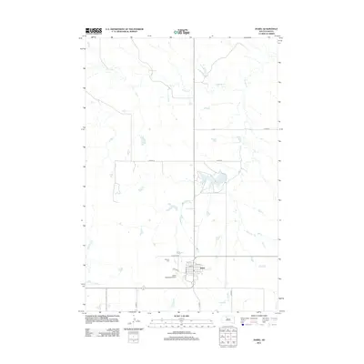
2012 Map of Isabel
USGS Topo · Published 2012About this map
Isabel serves as a central hub in Ziebach County, characterized by a structured street grid that includes Railway St, 3rd St, and E 4th St. The town's layout reflects its development as a regional service point, supported by the Isabel Municipal Airport situated on its southern edge. To the north and east, the landscape is defined by the winding paths of Firesteel Cr and Meadow Cr, which drain into several small reservoirs and larger bodies like Isabel Lake. This 2012 survey illustrates the modern configuration of the plains, where rural county roads like Co Hwy-1A and Co Hwy-1B connect isolated farmsteads to the community center. For those researching local roots, the Hillview Cem on the western approach to town provides a significant genealogical reference point.
Find a feature on this map
18 named features on this map. Tap any name to fly to it.
Don’t see what you’re looking for? This feature index may not catch every label — zoom into the map to look around manually.
Map Details
Editions of this 2012 Isabel Map
This is the sole edition of this map. No revisions or reprints were ever made.
Other maps of this area

1953 · McIntosh
USGS Topo · 1:250,000

1956 · Black Horse SW
USGS Topo · 1:24,000

1956 · Black Horse SE
USGS Topo · 1:24,000

1956 · Cottonwood Creek SE
USGS Topo · 1:24,000

1958 · McIntosh
USGS Topo · 1:250,000

1978 · Isabel SW
USGS Topo · 1:24,000

1978 · Peach Lake
USGS Topo · 1:24,000

1978 · Isabel
USGS Topo · 1:24,000
1978 · Firesteel
USGS Topo · 1:24,000

1980 · McIntosh
USGS Topo · 1:100,000