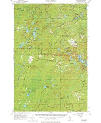
1955 Map of Isabella
USGS Topo · Published 1976About this map
The Duluth Missabe and Iron Range Railroad carves through this densely forested landscape in Lake County, serving as a vital industrial artery for the region's logging and mining activities. This mid-century survey reveals a transition in settlement, where places like the Isabella Sch (Abandoned) and the Isabella (Station) mark the shift from established community hubs to more specialized outposts. Within the Superior National Forest and Minnesota State Forest, the map identifies several remote water-access points including Martin Landing, Kelly Landing, and Sawbill Landing. The topography is dotted with dozens of glacial lakes, from Sphagnum Lake in the northwest to the larger Tanner Lake in the east. Historic infrastructure such as the Stony Lookout Tower and the Ranger Station highlight the era's fire prevention and land management efforts, while Murphy City and Manitou Junction anchor the southern rail connections.
Find a feature on this map
94 named features on this map. Tap any name to fly to it.
Don’t see what you’re looking for? This feature index may not catch every label — zoom into the map to look around manually.
Map Details
Editions of this 1955 Isabella Map
4 editions found
Other maps of this area

1953 · Whyte
USGS Topo · 1:62,500

1954 · Greenwood Lake
USGS Topo · 1:62,500

1954 · Silver Bay
USGS Topo · 1:62,500

1954 · Two Harbors
USGS Topo · 1:250,000

1955 · Isabella
USGS Topo · 1:62,500

1955 · Cramer
USGS Topo · 1:62,500

1956 · Finland
USGS Topo · 1:24,000

1956 · Finland
USGS Topo · 1:62,500

1957 · Two Harbors
USGS Topo · 1:250,000

1957 · Gabbro Lake
USGS Topo · 1:62,500