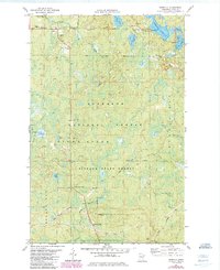
1981 Map of Isabella
USGS Topo · Published 1985About this map
Isabella serves as the primary focal point in this portion of the Arrowhead Region, situated at the junction of the Stony River and Beaver Bay townships. The settlement's local infrastructure is anchored by the Isabella Union Chapel and the Isabella Memorial Cem, while the surrounding landscape of the Superior National Forest and Finland State Forest is defined by its industrial history. Multiple rail lines tell the story of Northwoods extraction, including the General Logging Railroad and a Mining Railroad, along with numerous segments marked as Old Railroad Grade. This network of transport once connected remote camps to the wider region. Further south, near Murphy City, the Baptism River and its West Branch flow toward Baptism Crossing, illustrating the hydrology of a landscape dominated by timber and mineral interests.
Find a feature on this map
44 named features on this map. Tap any name to fly to it.
Don’t see what you’re looking for? This feature index may not catch every label — zoom into the map to look around manually.
Map Details
Editions of this 1981 Isabella Map
2 editions found
Other maps of this area

1954 · Silver Bay
USGS Topo · 1:62,500

1954 · Two Harbors
USGS Topo · 1:250,000

1955 · Isabella
USGS Topo · 1:62,500

1955 · Cramer
USGS Topo · 1:62,500

1956 · Finland
USGS Topo · 1:24,000

1956 · Finland
USGS Topo · 1:62,500

1957 · Two Harbors
USGS Topo · 1:250,000

1958 · Two Harbors
USGS Topo · 1:250,000

1964 · Two Harbors
USGS Topo · 1:250,000

1976 · Two Harbors
USGS Topo · 1:100,000
Featured Places
- Stony River Township, MN
- Manitou Junction, MN
- Beaver Bay Township, MN
- Murphy City, MN
- Crystal Bay Township, MN