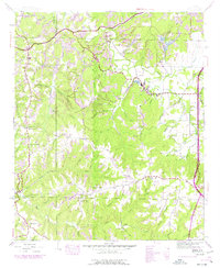
1945 Map of Isbell
USGS Topo · Published 1977About this map
The Old Chickasaw Boundary cuts across the northern edge of this Franklin County landscape, marking a significant historical line in the settlement of northwest Alabama. The area is defined by a dense network of waterways including Cedar Creek, Bear Creek, and Little Creek, which carve through the terrain between the communities of Belgreen and Isbell. Industrial activity is evident in the northern reaches where a Strip Mine and associated Tailings ponds appear near the Southern Railway corridor.
Find a feature on this map
63 named features on this map. Tap any name to fly to it.
Don’t see what you’re looking for? This feature index may not catch every label — zoom into the map to look around manually.
Map Details
Editions of this 1945 Isbell Map
3 editions found
Other maps of this area

1924 · Tuscumbia
USGS Topo · 1:48,000

1925 · Barton
USGS Topo · 1:62,500

1926 · Tuscumbia
USGS Topo · 1:62,500

1926 · Barton
USGS Topo · 1:48,000

1929 · Barton
USGS Topo · 1:62,500

1936 · Russellville
USGS Topo · 1:24,000

1936 · Frankfort
USGS Topo · 1:24,000

1936 · Pleasant Grove
USGS Topo · 1:24,000

1936 · Hodges
USGS Topo · 1:24,000

1936 · Isbell
USGS Topo · 1:24,000