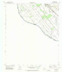
1972 Map of Isla
USGS Topo · Published 1974About this map
San Elizario Island dominates this international boundary landscape along the Rio Grande, where the river separates Texas from Chihuahua. The intricate network of irrigation and drainage features, including the Guadalupe Border Drain and Fabens Drain, illustrates the highly engineered agricultural system necessary for farming this river valley in the early 1970s. The settlement of Fabens serves as a local hub, anchored by the Southern Pacific railroad line and a Jr High Sch. Near the southern edge of the quadrangle, the Guadalupe Bridge provides a vital crossing point adjacent to the US Customs station. The geography here is defined by these water-management structures, like the Hansen Lateral and Island Drain, which weave between small homesteads and orchards on the alluvial plain. Genealogists may find value in the local Cemetery and the specific placement of gaging stations and sewage disposal facilities that reflect the community's infrastructure during this era.
Find a feature on this map
26 named features on this map. Tap any name to fly to it.
Don’t see what you’re looking for? This feature index may not catch every label — zoom into the map to look around manually.
Map Details
Editions of this 1972 Isla Map
This is the sole edition of this map. No revisions or reprints were ever made.
Other maps of this area

1896 · El Paso
USGS Topo · 1:125,000

1896 · Rio Grande
USGS Topo · 1:125,000

1908 · El Paso
USGS Topo · 1:125,000

1939 · Ysleta
USGS Topo · 1:62,500

1941 · Clint
USGS Topo · 1:62,500

1941 · Ysleta
USGS Topo · 1:62,500

1941 · Tornillo
USGS Topo · 1:62,500

1945 · Ysleta
USGS Topo · 1:62,500
1945 · Clint
USGS Topo · 1:62,500
1945 · Tornillo
USGS Topo · 1:62,500