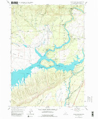
1964 Map of Island Park Dam
USGS Topo · Published 1979About this map
Island Park Dam and its adjacent Island Park Reservoir dominate this 1964 Idaho landscape, serving as a central hub for water management and recreation within the Targhee National Forest. The map details the intricate shoreline of the reservoir, including the large I P Bills Island and numerous specialized sites like Jackson Landing Campground and the Buttermilk Campground. The flow of the Henrys Fork is a primary geographical feature, winding past landmarks such as Coffee Pot Rapids and under the Mile 102 Footbridge.
Find a feature on this map
61 named features on this map. Tap any name to fly to it.
Don’t see what you’re looking for? This feature index may not catch every label — zoom into the map to look around manually.
Map Details
Editions of this 1964 Island Park Dam Map
3 editions found
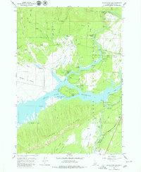
Other maps of this area

1950 · Upper Red Rock Lake
USGS Topo · 1:62,500

1955 · Ashton
USGS Topo · 1:250,000

1958 · Ashton
USGS Topo · 1:250,000

1960 · Ashton
USGS Topo · 1:250,000

1964 · Hatchery Butte
USGS Topo · 1:24,000

1964 · Island Park
USGS Topo · 1:24,000

1964 · Island Park Dam
USGS Topo · 1:24,000

1964 · Sawtell PK
USGS Topo · 1:24,000

1964 · Big Springs
USGS Topo · 1:24,000

1964 · Last Chance
USGS Topo · 1:24,000