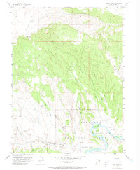
1955 Map of Island Park
USGS Topo · Published 1973About this map
Green River carves a dramatic path through the southern half of this mid-century survey, creating a series of river islands and meadows. Within the boundaries of Dinosaur National Monument, the landscape transitions from the high peaks of Diamond Mountain and Diamond Gulch in the north to the fertile river bottoms of Island Park and Rainbow Park. The topography is defined by a series of long, name-heavy drainage systems such as Boone Draw, Sixmile Draw, and Rainbow Draw, which channel runoff toward the river basin.
Find a feature on this map
47 named features on this map. Tap any name to fly to it.
Don’t see what you’re looking for? This feature index may not catch every label — zoom into the map to look around manually.
Map Details
Editions of this 1955 Island Park Map
3 editions found
Other maps of this area

1885 · Ashley
USGS Topo · 1:250,000

1907 · Jensen
USGS Topo · 1:125,000

1910 · Jensen
USGS Topo · 1:125,000

1950 · Blair Basin
USGS Topo · 1:24,000

1954 · Vernal
USGS Topo · 1:250,000

1955 · Island Park
USGS Topo · 1:24,000

1955 · Stuntz Reservoir
USGS Topo · 1:24,000

1955 · Jones Hole
USGS Topo · 1:24,000

1955 · Split Mountain
USGS Topo · 1:24,000

1958 · Vernal
USGS Topo · 1:250,000