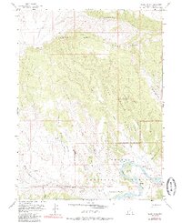
1955 Map of Island Park
USGS Topo · Published 1985About this map
Dinosaur National Monument encompasses the southern half of this map, where the Green River carves through the high desert. In the mid-1950s, the landscape was a blend of federally protected wilderness and isolated ranching outposts like Ruple Ranch. The river loops around prominent features such as Ford Island and Tree Island, creating lush riparian zones like Upper Meadow and Lower Meadow that contrast sharply with the surrounding arid uplands. To the north, Diamond Mountain rises above the basin, defined by deep incisions like Diamond Gulch and the aptly named Graveyard Ridge. This map illustrates the vital importance of water in the Uintah Basin, tracking every reliable source from Boone Spr to McKee Spr. The terrain is marked by ancient drainage patterns including Stone Bridge Draw and Six Mile Rough Draw, providing a detailed look at the geography of Island Park and Rainbow Park.
Find a feature on this map
35 named features on this map. Tap any name to fly to it.
Don’t see what you’re looking for? This feature index may not catch every label — zoom into the map to look around manually.
Map Details
Editions of this 1955 Island Park Map
3 editions found
Other maps of this area

1885 · Ashley
USGS Topo · 1:250,000

1907 · Jensen
USGS Topo · 1:125,000

1910 · Jensen
USGS Topo · 1:125,000

1950 · Blair Basin
USGS Topo · 1:24,000

1954 · Vernal
USGS Topo · 1:250,000

1955 · Island Park
USGS Topo · 1:24,000

1955 · Stuntz Reservoir
USGS Topo · 1:24,000

1955 · Jones Hole
USGS Topo · 1:24,000

1955 · Split Mountain
USGS Topo · 1:24,000

1958 · Vernal
USGS Topo · 1:250,000