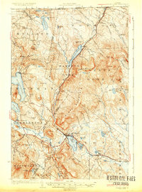
1926 Map of Island Pond
USGS Topo · Published 1926About this map
The Grand Trunk Railway dictates the settlement pattern of this Northeast Kingdom landscape, carving a vital corridor through the highlands from Norton Mills on the Canadian border down to Island Pond. In this era, the village of Island Pond serves as a primary hub, situated between its namesake water body and Back Pond. The surrounding terrain is a mosaic of steep ridges and numerous water bodies, including Seymour Lake and Holland Pond, which supported a timber-and-transit economy. Smaller hamlets and rail stops like Wenlock and East Brighton are connected by the tracks, while the interior is dotted with remote outposts such as Carpenters Big Camp. Local life is further evidenced by a high density of rural schoolhouses, including the Dennicks Mill School, Bazzinet School, and Buck School, which served the scattered families living in the shadows of Bluff Mountain and Gore Mtn.
Find a feature on this map
107 named features on this map. Tap any name to fly to it.
Don’t see what you’re looking for? This feature index may not catch every label — zoom into the map to look around manually.
Map Details
Editions of this 1926 Island Pond Map
4 editions found
Other maps of this area

1919 · Lake Memphremagog
USGS Topo · 1:62,500

1920 · Derby
USGS Topo · 1:62,500

1920 · Guildhall
USGS Topo · 1:62,500

1923 · Lake Memphremagog
USGS Topo · 1:48,000

1924 · Island Pond
USGS Topo · 1:48,000

1925 · Memphremagog
USGS Topo · 1:62,500

1926 · Island Pond
USGS Topo · 1:62,500

1929 · Averill
USGS Topo · 1:62,500

1931 · Guildhall
USGS Topo · 1:48,000

1933 · Guildhall
USGS Topo · 1:48,000