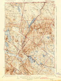
1926 Map of Island Pond
USGS Topo · Published 1943About this map
Island Pond serves as a critical rail junction in the Northeast Kingdom, where the Grand Trunk Railway and Canadian Pacific Railway converge amidst a landscape of glacial lakes and granite peaks. This 1920s survey captures the region's transition from timber dominance to a settled network of rural communities like Norton Mills and East Charleston. The map meticulously records the human geography of the Vermont-Quebec border, showing numerous local education centers such as Demicks Mill School, Echo School, and Iron Bridge School. The topography is dominated by the massive profile of Bluff Mountain and Gore Mtn, the latter featuring a fire tower. Water remains the primary shaper of travel and industry here, from the expansive Seymour Lake to the headwaters of the Nulhegan River and the Clyde River, which provided the necessary power for early mills and settlements.
Find a feature on this map
101 named features on this map. Tap any name to fly to it.
Don’t see what you’re looking for? This feature index may not catch every label — zoom into the map to look around manually.
Map Details
Editions of this 1926 Island Pond Map
4 editions found

Other maps of this area

1919 · Lake Memphremagog
USGS Topo · 1:62,500

1920 · Derby
USGS Topo · 1:62,500

1920 · Guildhall
USGS Topo · 1:62,500

1923 · Lake Memphremagog
USGS Topo · 1:48,000

1924 · Island Pond
USGS Topo · 1:48,000

1925 · Memphremagog
USGS Topo · 1:62,500

1926 · Island Pond
USGS Topo · 1:62,500

1929 · Averill
USGS Topo · 1:62,500

1931 · Guildhall
USGS Topo · 1:48,000

1933 · Guildhall
USGS Topo · 1:48,000