
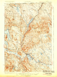
1926 Map of Island Pond
USGS Topo · Published 1936About this map
The Grand Trunk Railway corridor defines this portion of the Northeast Kingdom, threading through the narrow valley between Bluff Mountain and the peaks of Warrens Gore. This 1920s landscape reveals a remote timber and rail economy, where the village of Island Pond serves as a critical junction and population center. The map captures an era of extensive rural education, preserving the locations of numerous small schoolhouses like Dennicks Mill School, Iron Bridge School, and Cargill School that once served these mountain communities. High-elevation vantage points are marked by the Gore Mtn Fire Tower and Bald Mtn Fire Tower, overseeing a terrain dense with glacial ponds and named summits such as Mt John and Dollif Mtn. The international boundary at the top of the sheet shows the transition from Norton Mills into Canada, while the southern reaches include the remote settlements of East Brighton and Wenlock.
Find a feature on this map
100 named features on this map. Tap any name to fly to it.
Don’t see what you’re looking for? This feature index may not catch every label — zoom into the map to look around manually.
Map Details
Editions of this 1926 Island Pond Map
4 editions found
Other maps of this area

1919 · Lake Memphremagog
USGS Topo · 1:62,500

1920 · Derby
USGS Topo · 1:62,500

1920 · Guildhall
USGS Topo · 1:62,500

1923 · Lake Memphremagog
USGS Topo · 1:48,000

1924 · Island Pond
USGS Topo · 1:48,000

1925 · Memphremagog
USGS Topo · 1:62,500

1926 · Island Pond
USGS Topo · 1:62,500

1929 · Averill
USGS Topo · 1:62,500

1931 · Guildhall
USGS Topo · 1:48,000

1933 · Guildhall
USGS Topo · 1:48,000