
1968 Map of Isle SW
USGS Topo · Published 1970About this map
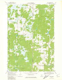
Mille Lacs State Wildlife Management Area dominates the southern reaches of this landscape on the border of Mille Lacs and Kanabec counties. Photogrammetric methods from 1966 aerial photography reveal a complex network of wetlands and wooded terrain, with the Knife River and Ernst Pool providing a defined water system. The map documents localized industrial footprints, such as a Quarry and various Gravel Pits, indicating small-scale extraction within the rural townships. Further north, the Isle Harbor Lookout Tower stands as a prominent landmark within Isle Harbor, overlooking the low-lying reaches of Hay Brook. This survey illustrates the land use patterns of the late 1960s, where traditional resource management and conservation areas intersect in a sparsely populated section of central Minnesota.
Find a feature on this map
11 named features on this map. Tap any name to fly to it.
Don’t see what you’re looking for? This feature index may not catch every label — zoom into the map to look around manually.
Map Details
Editions of this 1968 Isle SW Map
2 editions found
Other maps of this area

1953 · Duluth
USGS Topo · 1:250,000

1953 · Stillwater
USGS Topo · 1:250,000

1955 · Stillwater
USGS Topo · 1:250,000

1958 · Stillwater
USGS Topo · 1:250,000

1958 · Duluth
USGS Topo · 1:250,000

1965 · Stillwater
USGS Topo · 1:250,000

1968 · Milaca NE
USGS Topo · 1:24,000

1968 · Ann Lake
USGS Topo · 1:24,000

1968 · Wahkon North
USGS Topo · 1:24,000

1968 · Mora North
USGS Topo · 1:24,000