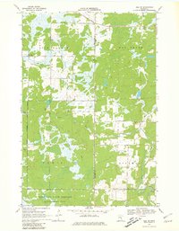
1968 Map of Isle SW
USGS Topo · Published 1981About this map
The Mille Lacs State Wildlife Management Area anchors the southern portion of this landscape, where the boundary between Mille Lacs and Kanabec counties cuts through a terrain defined by complex wetland systems and small watercourses. The drainage of the Knife River and Hay Brook dominates the central and northern sections, reflecting the glaciated topography of central Minnesota in the late 1960s. Surveyed for the township divisions of Isle Harbor, Lewis, and Hillman, the map reveals a sparsely populated region primarily utilized for conservation and resource extraction. Human presence is marked by the Isle Harbor Lookout Tower and scattered industrial sites, including a Quarry and multiple Gravel Pits, which suggest the local importance of aggregate mining within this heavily forested and marshy environment.
Find a feature on this map
12 named features on this map. Tap any name to fly to it.
Don’t see what you’re looking for? This feature index may not catch every label — zoom into the map to look around manually.
Map Details
Editions of this 1968 Isle SW Map
2 editions found
Other maps of this area

1953 · Duluth
USGS Topo · 1:250,000

1953 · Stillwater
USGS Topo · 1:250,000

1955 · Stillwater
USGS Topo · 1:250,000

1958 · Stillwater
USGS Topo · 1:250,000

1958 · Duluth
USGS Topo · 1:250,000

1965 · Stillwater
USGS Topo · 1:250,000

1968 · Milaca NE
USGS Topo · 1:24,000

1968 · Ann Lake
USGS Topo · 1:24,000

1968 · Isle SW
USGS Topo · 1:24,000

1968 · Wahkon North
USGS Topo · 1:24,000