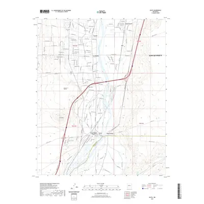
2020 Map of Isleta
USGS Topo · Published 2020About this map
The Rio Grande flows south through this part of Bernalillo County, creating a fertile valley corridor flanked by the arid elevations of Mesa de los Padillas and Black Mesa. This area is defined by the historic lands of Isleta Pueblo, where the primary settlement at Isleta Village Proper sits near the river's edge. To the north, the transition toward the southern reaches of Albuquerque is marked by the established communities of Los Padillas, Pajarito, and Mountainview. Local genealogy is well-supported by the presence of the Isleta Cem, Los Padillas Cem, and Pajarito Cem, which serve these long-standing river valley settlements. The landscape is further shaped by complex water management features like the Isleta Drain, while the southeastern corner is carved by the seasonal drainage of Hells Canyon Wash.
Find a feature on this map
100 named features on this map. Tap any name to fly to it.
Don’t see what you’re looking for? This feature index may not catch every label — zoom into the map to look around manually.
Map Details
Editions of this 2020 Isleta Map
This is the sole edition of this map. No revisions or reprints were ever made.
Other maps of this area

1888 · Bernalillo
USGS Topo · 1:125,000

1889 · Albuquerque
USGS Topo · 1:125,000

1893 · Albuquerque
USGS Topo · 1:125,000

1934 · West Albuquerque
USGS Topo · 1:24,000

1934 · East Albuquerque
USGS Topo · 1:24,000

1938 · Albuquerque
USGS Topo · 1:62,500

1952 · Wind Mesa
USGS Topo · 1:24,000

1952 · Dalies
USGS Topo · 1:24,000

1952 · Hubbell Spring
USGS Topo · 1:24,000

1952 · Los Lunas SE
USGS Topo · 1:24,000