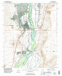
1991 Map of Isleta
USGS Topo · Published 1996About this map
The Isleta Pueblo serves as a central landmark within this portion of the Isleta Indian Reservation, situated where the Rio Grande flows southward through the valley. The landscape is defined by an intricate network of water management features, including the Isleta Drain, Main Canal, and the Belen High Line Canal, supporting agriculture in communities like Los Padillas and Pajarito. These settlements are rooted in deep history, with the ancient El Camino Real and the modern Pan American Highway traversing the terrain parallel to the river.
Find a feature on this map
38 named features on this map. Tap any name to fly to it.
Don’t see what you’re looking for? This feature index may not catch every label — zoom into the map to look around manually.
Map Details
Editions of this 1991 Isleta Map
This is the sole edition of this map. No revisions or reprints were ever made.
Other maps of this area

1888 · Bernalillo
USGS Topo · 1:125,000

1889 · Albuquerque
USGS Topo · 1:125,000

1893 · Albuquerque
USGS Topo · 1:125,000

1934 · West Albuquerque
USGS Topo · 1:24,000

1934 · East Albuquerque
USGS Topo · 1:24,000

1938 · Albuquerque
USGS Topo · 1:62,500

1952 · Wind Mesa
USGS Topo · 1:24,000

1952 · Dalies
USGS Topo · 1:24,000

1952 · Hubbell Spring
USGS Topo · 1:24,000

1952 · Los Lunas SE
USGS Topo · 1:24,000