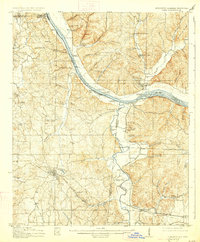
1914 Map of Iuka
USGS Topo · Published 1927About this map
Iuka serves as the focal point of this tri-state survey, situated where the Southern railroad cuts across the Tennessee Hills. The landscape is defined by the winding course of the Tennessee River and its numerous tributaries, including Bear Creek and Yellow Creek. This era of river travel is documented through a dense network of landings like Evans Landing and Shellbank Landing, which provided vital shipping points for local cotton and timber before modern bridge infrastructure dominated the region.
Find a feature on this map
124 named features on this map. Tap any name to fly to it.
Don’t see what you’re looking for? This feature index may not catch every label — zoom into the map to look around manually.
Map Details
Editions of this 1914 Iuka Map
4 editions found
Other maps of this area

1905 · Waynesboro
USGS Topo · 1:125,000

1911 · Iuka
USGS Topo · 1:48,000

1914 · Iuka
USGS Topo · 1:62,500

1924 · Gravelly Springs
USGS Topo · 1:48,000

1925 · Barton
USGS Topo · 1:62,500

1926 · Barton
USGS Topo · 1:48,000

1926 · Gravelly Springs
USGS Topo · 1:62,500

1929 · Barton
USGS Topo · 1:62,500

1935 · Cherokee
USGS Topo · 1:24,000

1935 · Holcut
USGS Topo · 1:24,000