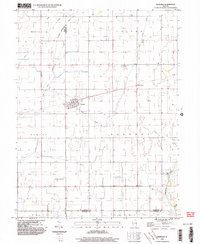
1998 Map of Ivesdale
USGS Topo · Published 2003About this map
The village of Ivesdale serves as the central hub of this agricultural landscape at the close of the 20th century, situated where the Lake Fork and its tributaries define the drainage of the Illinois prairie. The map illustrates a highly managed water system, featuring the Kankakee Drainage Ditch, the Special Lake Fork, and the East Fork Lake, reflecting generations of hydraulic engineering to support the fertile farm ground across the Piatt and Champaign County line.
Find a feature on this map
21 named features on this map. Tap any name to fly to it.
Don’t see what you’re looking for? This feature index may not catch every label — zoom into the map to look around manually.
Map Details
Editions of this 1998 Ivesdale Map
This is the sole edition of this map. No revisions or reprints were ever made.
Other maps of this area

1907 · Mahomet
USGS Topo · 1:62,500

1937 · Monticello
USGS Topo · 1:48,000

1943 · Monticello
USGS Topo · 1:62,500

1950 · Tuscola
USGS Topo · 1:62,500

1955 · Bement
USGS Topo · 1:62,500

1957 · Mahomet
USGS Topo · 1:62,500

1957 · Bondville
USGS Topo · 1:24,000

1958 · Peoria
USGS Topo · 1:250,000

1958 · Decatur
USGS Topo · 1:250,000

1961 · Peoria
USGS Topo · 1:250,000