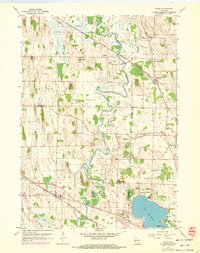
1959 Map of Ixonia
USGS Topo · Published 1972About this map
The Rock River and Ashippun River define the agricultural landscape of this region during the mid-20th century, where traditional rural life intersects with expanding infrastructure. The settlement of Ixonia serves as a local hub along the Chicago Milwaukee St Paul and Pacific railroad, while the northern reaches show the distinct separation between Old Ashippun and the newer center of Ashippun. Significant local landmarks include the Monastery near the shores of Lac La Belle and various country schools such as Cross Sch and the Pennsylvania Street Sch. The presence of numerous Gravel Pits throughout the town of Lebanon and surrounding areas indicates a landscape undergoing physical change, likely supporting the development of local roads and highway improvements. This survey captures a moment when family-named landmarks like Sugar Island and Davy Creek remained central to the geographic identity of the county borderlands.
Find a feature on this map
42 named features on this map. Tap any name to fly to it.
Don’t see what you’re looking for? This feature index may not catch every label — zoom into the map to look around manually.
Map Details
Editions of this 1959 Ixonia Map
2 editions found
Other maps of this area

1892 · Watertown
USGS Topo · 1:62,500

1892 · Oconomowoc
USGS Topo · 1:62,500

1894 · Watertown
USGS Topo · 1:62,500

1904 · Hartford
USGS Topo · 1:62,500

1909 · Oconomowoc
USGS Topo · 1:62,500

1955 · Horicon
USGS Topo · 1:62,500

1957 · Madison
USGS Topo · 1:250,000
1959 · Helenville
USGS Topo · 1:24,000

1959 · Ixonia
USGS Topo · 1:24,000
1959 · Oconomowoc East
USGS Topo · 1:24,000