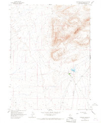
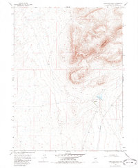
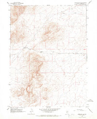
1965 Map of Izzenhood Ranch
USGS Topo · Published 1967About this map
Izzenhood Ranch serves as the focal point of this Nevada landscape, situated in a high-desert environment characterized by large ranches and expansive open range. The terrain is dominated by the prominent geological formation of Roosters Comb, where sharp elevation changes contrast with the flatter basins of the surrounding high plateau. The infrastructure reflects the mid-century ranching economy, with water access provided by Lander Well and transit facilitated by the unpaved Izzenhood Road and various Jeep Trails. Surveyed in the early 1960s, the map documents a sparse but deliberate settlement pattern common to Lander County, where life centered around established ranching headquarters and critical water sources in an arid climate.
Find a feature on this map
9 named features on this map. Tap any name to fly to it.
Don’t see what you’re looking for? This feature index may not catch every label — zoom into the map to look around manually.
Map Details
Editions of this 1965 Izzenhood Ranch Map
2 editions found
Other maps of this area

1882 · Paradise
USGS Topo · 1:250,000

1893 · Paradise
USGS Topo · 1:250,000

1932 · Sonoma Range
USGS Topo · 1:250,000

1939 · Sonoma Range
USGS Topo · 1:250,000

1955 · McDermitt
USGS Topo · 1:250,000

1955 · Winnemucca
USGS Topo · 1:250,000

1958 · Winnemucca
USGS Topo · 1:250,000

1959 · McDermitt
USGS Topo · 1:250,000

1962 · Winnemucca
USGS Topo · 1:250,000
1965 · Izzenhood Gap
USGS Topo · 1:24,000