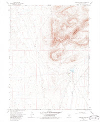
1965 Map of Izzenhood Ranch
USGS Topo · Published 1985About this map
Izzenhood Ranch sits at the base of the high desert slopes in this mid-1960s survey of Lander County. The landscape is defined by the prominent Roosters Comb formation, which rises sharply above the surrounding basin. This area represents the isolated livestock and water-management culture of the Great Basin, where critical water sources like Lander Well and high-elevation benchmarks such as Russell 4537 served as essential navigation and survival points for ranchers and surveyors alike. Travel through this arid terrain was facilitated by the primitive Izzenhood Road and various rugged Jeep Trails, illustrating the reliance on unpaved networks to connect these remote outposts to the wider region. The map provides a clear look at the topography before later modern developments, preserving the original layout of the ranch and its surrounding landmarks.
Find a feature on this map
11 named features on this map. Tap any name to fly to it.
Don’t see what you’re looking for? This feature index may not catch every label — zoom into the map to look around manually.
Map Details
Editions of this 1965 Izzenhood Ranch Map
2 editions found
Other maps of this area

1882 · Paradise
USGS Topo · 1:250,000

1893 · Paradise
USGS Topo · 1:250,000

1932 · Sonoma Range
USGS Topo · 1:250,000

1939 · Sonoma Range
USGS Topo · 1:250,000

1955 · McDermitt
USGS Topo · 1:250,000

1955 · Winnemucca
USGS Topo · 1:250,000

1958 · Winnemucca
USGS Topo · 1:250,000

1959 · McDermitt
USGS Topo · 1:250,000

1962 · Winnemucca
USGS Topo · 1:250,000

1965 · Izzenhood Gap
USGS Topo · 1:24,000