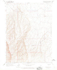
1965 Map of Izzenhood Spring
USGS Topo · Published 1967About this map
Sheep Creek Range dominates this landscape in Lander County, defining a high-altitude terrain where water sources are the primary points of interest. This 1960s survey records the vital water points necessary for survival and ranching in the Great Basin, notably Izzenhood Spring and an additional unnamed Spring located further north. These features represent critical infrastructure for a high-desert environment where drainage patterns like Sheep Creek are often ephemeral. Prominent peaks such as Workhorse Butte and Sterritt Peak serve as primary navigational landmarks across the rugged topography. The absence of roads and settlements on this sheet emphasizes the isolation of the area during this era, serving as a record of the land before modern developments changed the character of the high desert.
Find a feature on this map
6 named features on this map. Tap any name to fly to it.
Don’t see what you’re looking for? This feature index may not catch every label — zoom into the map to look around manually.
Map Details
Editions of this 1965 Izzenhood Spring Map
This is the sole edition of this map. No revisions or reprints were ever made.
Other maps of this area

1955 · Winnemucca
USGS Topo · 1:250,000

1957 · Dunphy
USGS Topo · 1:62,500

1957 · Battle Mountain
USGS Topo · 1:62,500

1958 · Winnemucca
USGS Topo · 1:250,000

1962 · Winnemucca
USGS Topo · 1:250,000

1965 · Izzenhood Gap
USGS Topo · 1:24,000

1965 · Russells
USGS Topo · 1:24,000

1965 · Sheep Creek Range SW
USGS Topo · 1:24,000

1965 · Sheep Creek Range NW
USGS Topo · 1:24,000
1965 · Izzenhood Ranch
USGS Topo · 1:24,000