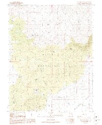
1986 Map of Jack Henry Knoll
USGS Topo · Published 1986About this map
Black Mountains terrain dominates this iron-rich corridor of southern Utah, where high peaks and deep canyons dictate the movement of both water and wildlife. Named landmarks like Jack Henry Knoll and Chipman Peak suggest a landscape shaped by local ranching and prospecting history, with numerous seeps and springs serving as vital lifeblood for the arid environment. A network of unimproved roads and trails connects remote water sources such as Jackrabbit Spring and North Kane Spring, providing a clear record of how this backcountry was accessed in the mid-1980s.
Find a feature on this map
26 named features on this map. Tap any name to fly to it.
Don’t see what you’re looking for? This feature index may not catch every label — zoom into the map to look around manually.
Map Details
Editions of this 1986 Jack Henry Knoll Map
This is the sole edition of this map. No revisions or reprints were ever made.
Other maps of this area

1885 · Beaver
USGS Topo · 1:250,000

1886 · Kanab
USGS Topo · 1:250,000

1953 · Minersville
USGS Topo · 1:24,000

1953 · Richfield
USGS Topo · 1:250,000

1953 · Cedar City
USGS Topo · 1:250,000

1958 · Richfield
USGS Topo · 1:250,000

1958 · Cedar City
USGS Topo · 1:250,000

1958 · Minersville
USGS Topo · 1:62,500

1962 · Cedar City
USGS Topo · 1:250,000

1971 · Buckhorn Flat
USGS Topo · 1:24,000