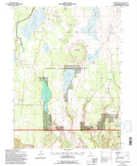
1993 Map of Jacks Butte
USGS Topo · Published 1996About this map
Jacks Butte rises as a prominent landmark in the high desert landscape of the Modoc National Forest, marking a region defined by complex water management and cattle ranching. This late twentieth-century survey reveals a network of man-made and natural water sources essential for livestock and wildlife, including Antelope Reservoir, Dobe Swale Reservoir, and several specialized catchments like Little Porcupine Tank. The presence of the Hastings Ranch and E Ranch in the southern portion of the quadrangle highlights the enduring pastoral utility of the land.
Find a feature on this map
25 named features on this map. Tap any name to fly to it.
Don’t see what you’re looking for? This feature index may not catch every label — zoom into the map to look around manually.
Map Details
Editions of this 1993 Jacks Butte Map
2 editions found
Other maps of this area

1886 · Alturas
USGS Topo · 1:250,000

1892 · Alturas
USGS Topo · 1:250,000

1954 · Alturas
USGS Topo · 1:250,000

1958 · Alturas
USGS Topo · 1:250,000

1961 · Canby
USGS Topo · 1:62,500

1961 · Alturas
USGS Topo · 1:62,500

1962 · Alturas
USGS Topo · 1:250,000

1962 · Big Sage Reservoir
USGS Topo · 1:62,500

1962 · Jacks Butte
USGS Topo · 1:62,500

1965 · Alturas
USGS Topo · 1:250,000