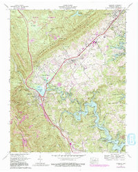
1973 Map of Jacksboro
USGS Topo · Published 1991About this map
Jacksboro and the adjacent industrial centers of La Follette and Caryville occupy a strategic corridor between the massive ridge of Cumberland Mountain and the rising waters of Norris Lake. This landscape is defined by the sharp transition from the level valley floors to the high, coal-bearing elevations of Fork Mountain and Walden Ridge. The 1973 revisions highlight the growing modern infrastructure, including Interstate 75 and the Campbell County Airport, while preserve traditional routes like the Old Kentucky Road.
Find a feature on this map
118 named features on this map. Tap any name to fly to it.
Don’t see what you’re looking for? This feature index may not catch every label — zoom into the map to look around manually.
Map Details
Editions of this 1973 Jacksboro Map
3 editions found
Other maps of this area

1893 · Briceville
USGS Topo · 1:125,000

1895 · Briceville
USGS Topo · 1:125,000

1896 · Briceville
USGS Topo · 1:125,000

1936 · Ivydell
USGS Topo · 1:24,000

1936 · Block
USGS Topo · 1:24,000

1936 · Jacksboro
USGS Topo · 1:24,000

1936 · Pioneer
USGS Topo · 1:24,000

1936 · Duncan Flats
USGS Topo · 1:24,000

1936 · La Follette
USGS Topo · 1:48,000

1936 · Norris Dam
USGS Topo · 1:48,000