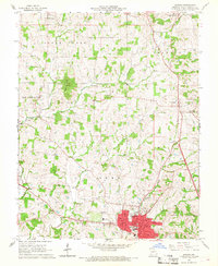
1966 Map of Jackson
USGS Topo · Published 1968About this map
Jackson serves as the focal point of this mid-1960s survey, showing its street grid and development just west of Interstate 55. The Missouri Pacific railroad cuts through the southern part of town, passing the local High Sch and Jr High Sch. The surrounding landscape is defined by the drainages of Byrd Creek, Hubble Creek, and Whitewater Creek, which carve through the townships of Apple Creek, Shawnee, and Whitewater. Numerous family and community burial grounds, such as Clippard Cem, Byrd Cem, and Russell Cem, are scattered across the rural acreage between the settlements of Fruitland and Pocahontas. Local social centers like St Johns Ch and the Drive-in Theater near the highway reflect the mid-century character of the region. This document preserves the locations of established landmarks including the Courthouse and several rural schools like the R-2 School, illustrating the infrastructure of Cape Girardeau County before modern expansion.
Find a feature on this map
51 named features on this map. Tap any name to fly to it.
Don’t see what you’re looking for? This feature index may not catch every label — zoom into the map to look around manually.
Map Details
Editions of this 1966 Jackson Map
2 editions found
Other maps of this area

1918 · Altenburg
USGS Topo · 1:62,500

1922 · Cape Girardeau
USGS Topo · 1:62,500

1923 · Perryville
USGS Topo · 1:62,500

1924 · Cape Girardeau
USGS Topo · 1:62,500

1924 · Perryville
USGS Topo · 1:62,500

1925 · Altenburg
USGS Topo · 1:62,500

1933 · Marble Hill
USGS Topo · 1:62,500

1937 · Marble Hill
USGS Topo · 1:62,500

1947 · Oak Ridge
USGS Topo · 1:24,000

1947 · Altenburg
USGS Topo · 1:62,500