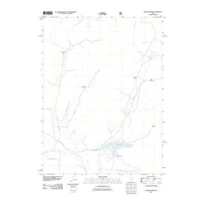
2011 Map of Jackson Draw
USGS Topo · Published 2011About this map
Matt Warner Reservoir serves as a central hydrological landmark in this high-desert landscape of Uintah County, regulated by the Matt Warner Dam. The terrain is defined by a network of drainage systems, including the prominent Jackson Draw, Davenport Draw, and several named hollows like Bear Hollow and Dry Hollow. Water sources are sparse but critical, evidenced by the presence of Serviceberry Spring and Bullpen Spring in the northern reaches of the quadrangle. Access to this territory is facilitated by a system of ranch and loop roads, such as Siddoway Ranch Rd and Slaugh Ranch Rd, which reflect the localized cattle and ranching economy. The map also traces the winding courses of Pot Creek and Simons Creek, which feed into the reservoir area, illustrating the essential relationship between water management and land use in this part of eastern Utah.
Find a feature on this map
23 named features on this map. Tap any name to fly to it.
Don’t see what you’re looking for? This feature index may not catch every label — zoom into the map to look around manually.
Map Details
Editions of this 2011 Jackson Draw Map
This is the sole edition of this map. No revisions or reprints were ever made.
Other maps of this area

1885 · Ashley
USGS Topo · 1:250,000

1950 · Burnt Cabin Gorge
USGS Topo · 1:24,000

1950 · Blair Basin
USGS Topo · 1:24,000

1952 · Warren Draw
USGS Topo · 1:24,000

1952 · Clay Basin
USGS Topo · 1:24,000

1952 · Dutch John Mtn
USGS Topo · 1:24,000

1952 · Goslin Mtn
USGS Topo · 1:24,000

1954 · Vernal
USGS Topo · 1:250,000

1958 · Vernal
USGS Topo · 1:250,000

1960 · Vernal
USGS Topo · 1:250,000