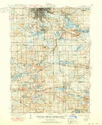
1939 Map of Jackson
USGS Topo · Published 1950About this map
Jackson anchors this South Central Michigan landscape, serving as a significant railroad junction where the Michigan Central, New York Central, and Cincinnati Northern lines converge. South of the city, the terrain is defined by a dense network of glacial lakes including Vandercook Lake, Browns Lake, and the expansive Clark Lake. The transition from urban center to rural townships is marked by numerous one-room schoolhouses like Turkey Hall Sch and Spring Brook Sch, which were the social pillars of the era's farming communities.
Find a feature on this map
106 named features on this map. Tap any name to fly to it.
Don’t see what you’re looking for? This feature index may not catch every label — zoom into the map to look around manually.
Map Details
Editions of this 1939 Jackson Map
4 editions found
Other maps of this area

1919 · Stockbridge
USGS Topo · 1:62,500

1919 · Springport
USGS Topo · 1:62,500

1919 · Rives Junction
USGS Topo · 1:62,500

1921 · Rives Junction
USGS Topo · 1:62,500

1921 · Springport
USGS Topo · 1:62,500

1922 · Stockbridge
USGS Topo · 1:62,500

1935 · Jackson
USGS Topo · 1:48,000

1939 · Jackson
USGS Topo · 1:62,500

1942 · Stockbridge
USGS Topo · 1:62,500

1948 · Spring Arbor
USGS Topo · 1:62,500