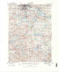
1983 Map of Jackson
USGS Topo · Published 1984About this map
The Conrail lines anchor this early 1980s landscape, connecting the industrial and academic hubs of South Central Michigan. The sheet is defined by its institutional and recreational anchors, from the State Prison Farm north of Jackson to Olivet College in the northwest corner. Vast conservation areas like the Waterloo State Recreation Area and Pinckney State Recreation Area highlight the glacial terrain of the region, characterized by a high density of kettle lakes such as Portage Lake and Duck Lake. Local history is preserved in sites like Minards Mill and Riverside Cem. The map illustrates the region's transition into a modern residential and recreational corridor while maintaining its traditional rail-and-agriculture bones, seen in the numerous small settlements like Eaton Rapids and Stockbridge that follow the established transit routes.
Find a feature on this map
172 named features on this map. Tap any name to fly to it.
Don’t see what you’re looking for? This feature index may not catch every label — zoom into the map to look around manually.
Map Details
Editions of this 1983 Jackson Map
This is the sole edition of this map. No revisions or reprints were ever made.
Historical Maps of Jackson Through Time
3 maps found