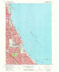
1963 Map of Jackson Park
USGS Topo · Published 1973About this map
The Chicago lakefront of the 1960s is defined by its massive park systems and cultural institutions, stretching from Grant Park down to Jackson Park. This survey reveals the dense urban infrastructure supporting the South Side, where the Illinois Central Gulf railroad parallels the coast, serving as a corridor for neighborhoods like Hyde Park and Woodlawn. The map captures a high-density institutional landscape, featuring the sprawling campus of the University of Chicago and the storied Oakwoods Cemetery.
Find a feature on this map
101 named features on this map. Tap any name to fly to it.
Don’t see what you’re looking for? This feature index may not catch every label — zoom into the map to look around manually.
Map Details
Editions of this 1963 Jackson Park Map
3 editions found
Other maps of this area

1889 · Chicago
USGS Topo · 1:62,500

1891 · Chicago
USGS Topo · 1:62,500

1892 · Calumet
USGS Topo · 1:62,500

1893 · Calumet
USGS Topo · 1:62,500

1900 · Chicago
USGS Topo · 1:62,500

1900 · Toleston
USGS Topo · 1:62,500

1900 · Calumet
USGS Topo · 1:62,500

1901 · Calumet
USGS Topo · 1:62,500

1901 · Chicago
USGS Topo · 1:62,500

1929 · Calumet Lake
USGS Topo · 1:24,000